
Topic: Jefferson's Public Life & Politics

Lesson Plan
Declaration of Independence Timeline Activity
The words “all men are created equal” have echoed throughout history. Since 1776, there have been approximately 120 declarations of independence made by different countries and different peoples. This activity...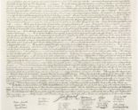

Media › document
Engraving of the Declaration of Independence
Engraving of the Declaration of Independence.
Article
Jefferson and Slavery
About 100 slaves lived and worked at Monticello at any given time. They plowed the fields, planted the wheat, and drove the wagons. They cared for the hogs and cows. Household slaves prepared food for Thomas Jefferson and his family. They washed his clothes and cared for his children. Despite writing the words "all men are created equal," Jefferson was a life-long slave owner who held over 600 humans in bondage throughout his lifetime.
Article
Jefferson and the Declaration of Independence
In early May, 1776, Jefferson traveled to Philadelphia to be a delegate to the Second Continental Congress. After a week’s journey, he arrived in Philadelphia. He was thirty-three years old, the youngest member of the Congress.
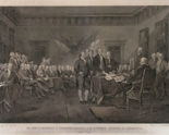
Media › image
The Declaration of Independence by John Trumbull
Engraving of the painting “The Declaration of Independence” by John Trumbull depicting the Committee of Five presenting the Declaration to the Second Continental Congress....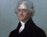
Media › image
‘Edgehill’ portrait of Thomas Jefferson
Painting of Thomas Jefferson by Gilbert StuartLesson Plan
“A Government Without Newspapers, or Newspapers Without Government:” Jefferson’s Ambivalent Attitude Towards the Press
With more and more discussion lately about “fake news” and the protections of the press guaranteed under the First Amendment, explore how Thomas Jefferson might approach the media today. Through...Lesson Plan
Jefferson, the Barbary War, and 9/11: Analyzing Constitutional Principles and Evaluating how America Goes to War
The Barbary War has often been overlooked in the study of American history, but there were significant precedents established by the decision made to take America into it’s first foreign...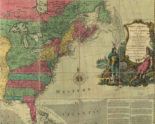
Media › image
Map of the British Colonies in North America in 1763
This map by Carington Bowles shows the boundaries of the American colonies in 1763 following the French and Indian Wars.
Media › image