
Topic: Lewis & Clark & the Louisiana Purchase

Article
Jefferson Prepares for the Lewis and Clark Expedition
Click the Middle Reading Level above to see a version for advanced upper elementary readers.


Media › image
Map of the Lewis and Clark Expedition
This map of the western part of the Lewis and Clark Expedition was drawn by Samuel Lewis (no relation to Meriwether) using drawings supplied by William Clark.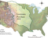
Media › image
Boundaries of the Louisiana Purchase
This map shows the boundaries of the Louisiana Purchase as recognized today. In 1802, the U.S. and its territories occupied most of the land to east.
Media › image
Elk Antlers
This set of Elk Antlers is one of the few surviving natural history specimens sent back from the Lewis and Clark Expedition
Lesson Plan
Jefferson’s Economic Plan for the Louisiana Territory
Developed for AP US History coursework. Can be adapted for any level.Lesson Plan
The wisdom of exchanging: What did Jefferson achieve through Westward expansion?
Who was the real Thomas Jefferson?Article
Thomas Jefferson: President of the United States
In 1800, Thomas Jefferson ran for president of the United States. John Adams also wanted to be president. Jefferson and Aaron Burr ran as Republicans. John Adams and Charles Pinkney ran as Federalists. There were many differences between the two groups.Republicans felt that the government belonged to all the people. They believed most people could…
Lesson Plan