
Topic: Geography

Media › document
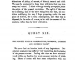
Notes on the State of Virginia
This document is an excerpt of Thomas Jefferson’s only book-length publication. Jefferson wrote the work during the early 1780s in response to a series of questions from Frenchman Francois de...
Lesson Plan
Monticello Topography: Let’s Make a Mountain
An introduction to visualizing the topography of Monticello in the classroom, using the mountain on which Monticello sits to find the angle of elevation to Montalto (the adjacent mountain that...Lesson Plan
It’s All French to Me
Exploring Jefferson’s relationship with France and how it impacted the founding of America and his legacy in our nationLesson Plan
Red Soil & Dimensional Analysis
An exploration of ternary graphs and the science behind the red soil at Monticello, and a journey through calculations which give us a better understanding of how much work the...Lesson Plan
Lewis and Clark: Explorers or Conquerors?
When Jefferson purchased the Louisiana territory from France, he commissioned Lewis and Clark to explore the new territory. What was the purpose behind this mission? Were they sent as explorers...Lesson Plan
Unconventional Enemies: Should the United States negotiate with terrorists?
This lesson plan helps students make connections between Thomas Jefferson’s handling of the Barbary Pirates and contemporary presidential actions toward unconventional enemies of the United States, including Jimmy Carter’s Iran...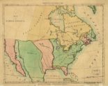
Media › image
A Map of North America
This map of North America was drawn not long before the Louisiana Purchase. The United States is shown here in green, with the Mississippi River as its western boundary. The...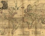
Media › image
A New Map of the World
This 1719 map provides a comprehensive overview of the world as it was understood in the early eighteenth century. Although the map accurately depicts the continents of Africa and Asia,...
Media › image